Maharashtra Mining Service Group B Syllabus PDF
महाराष्ट्र खनिज सेवा, गट-ब पदाकरीता अभ्यासक्रम प्रसिध्द
Maharashtra Mining Service Group B Syllabus PDF – Maharashtra Public Service Commission Organise Junior Geologist, Directorate of Geology and Mining, Maharashtra Mining Service, Group – B Examination every year. Candidates who wants to register for this Exam must Know About Maharashtra Mining Service Group B Syllabus and Exam Pattern, Junior Geologist Selection Process, Eductaional Criteria required for Junior Geologist Exam etc. In this article you will get all details regarding How MPSC Conducts Junior Geologist Exam, What is the Level of Junior Geologist Exam 2025 etc. Students are adviced to download whole Maharashtra Mining Service Group B Syllabus PDF through below Link. Go through Details Given below and boost Your Preparation with MahaBharti Exam Portal as we are Giving Daily FreeMPSC Mock Test..SO Keep Visiting Us…………. :
 MPSC New Syllabus And Exam Pattern PDF-Download For All Exam
 To Know Latest Changes And Updates in MPSC Exam Click Here
Maharashtra Mining Service Group B Syllabus and Exam Pattern
महाराष्ट्र लोकसेवा आयोग कनिष्ठ भूवैज्ञानिक, भूविज्ञान आणि खाण संचालनालय, महाराष्ट्र खाण सेवा, गट – ब परीक्षा दरवर्षी आयोजित करते. ज्या उमेदवारांना या परीक्षेसाठी नोंदणी करायची आहे त्यांनी महाराष्ट्र खाण सेवा गट ब अभ्यासक्रम आणि परीक्षा पद्धती, कनिष्ठ भूवैज्ञानिक निवड प्रक्रिया, कनिष्ठ भूवैज्ञानिक परीक्षेसाठी आवश्यक शैक्षणिक निकष इत्यादींबद्दल माहिती असणे आवश्यक आहे. या लेखात तुम्हाला MPSC ज्युनियर ग्रोलॉजिस्ट परीक्षाकशी असते याबद्दल सर्व तपशील मिळतील. विद्यार्थ्यांनी खालील लिंकवरून संपूर्ण महाराष्ट्र खाण सेवा गट बी अभ्यासक्रम PDF डाउनलोड करावा :
Maharashtra Mining Service Junior Geologist Exam Pattern
परीक्षेचे टप्पे :
१) लेखी परीक्षा – २०० गुण
२) मुलाखत ५० गुण
| विषय व सांकेतांक (९६७) | माध्यम | प्रश्नसंख्या | गुण | कालावधी | दर्जा | प्रश्नपत्रिकेचे स्वरुप |
| सामान्य ज्ञान | मराठी व इंग्रजी | १०० | २०० | १ तास | पदव्युत्तर पदवी | वस्तुनिष्ठ / बहुपर्यायी |
| भूविज्ञान व खनिकर्म | इंग्रजी |
१) प्रत्येक चुकीच्या उत्तराकरीता २५% किंवा १ / ४ एवढे गुण एकूण गुणांमधून वजा कमी करण्यात येतील.
२) एखाद्या प्रश्नाची एकापेक्षा अधिक उत्तरे दिली असल्यास अथवा ज्या उमेदवाराने उत्तरपत्रिकेत पूर्ण वर्तुळ चिन्हांकित नसेल अशा प्रश्नाचे उत्तर चुकीचे समजण्यात येऊन त्या प्रश्नाच्या उत्तराकरीता २५% किंवा १/४ एवढे गुण एकूण गुणांमधून वजा कमी करण्यात येतील.
३) वरीलप्रमाणे कार्यपध्दतीचा अवलंब करताना एकूण अंतिम गुणांची बेरीज अपूर्णांकात आली तरीही ती अपूर्णांकाच राहील व पुढील कार्यवाही त्याच्या आधारे करण्यात येईल.
४) एखाद्या प्रश्नाचे उत्तर अनुत्तरित असेल तर, अशा प्रकरणी नकारात्मक गुणांची पध्दत लागू असणार नाही.
५) अंतिम गुणवत्ता यादी ही वस्तुनिष्ठ परीक्षेतील व मुलाखतीतील एकत्रित गुणांवर आधारीत राहील.
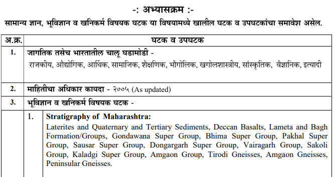
MPSC Junior Geologist Syllabus 2025

| 2. | Structural Geology:
Stratification. Attitude of beds. Outcrops and Outcrop patterns. Joints, Faults and Fractures classification and recognition. Folds – classification and recognition. Unconformities classification and recognition. Concept of foliation and lineation. Dykes and skills. |
| 3. | Petrology:
Sedimentary, Igneous and Metamorphic rocks – Basic classification. Grain size, angularity and nature of cement/matrix and its relation to porosity. Deccan Basalts – Lithostratigraphy, different type of lava flows, their classification and mapping. Nature of flow contacts, intertrappaean sediments, red boles, flow contact breccias, and their relation with aquifer/multiple aquifer system. Relationship of weathering and geochemistry of basalt and other rocks on water quality. |
| 4. | Geomorphology, Remote Sensing and Groundwater Exploration: |
|
|
a. Landform and Geomorphic processes:
Role of lithology, landforms and geology, Geomorphic cycles. Weathering and soil formation. Erosion. Landforms, slopes and drainage patterns. Peneplanation, endogenous and exogenous processes and forces responsible. Morphometric analysis. Geomorphic features and River systems of Maharashtra. |
|
|
b. Remote Sensing : Use and interpretation of aerial photographs. Thematic Maps and Satellite Imagery. Indian Remote Sensing (IRS) satellites. Imageries – IRS products, MSS band – blue, green, red and near infra red, False Colour Composite (FCC). Principles and applications of Geographic Information System (GIS) and Image Processing. Droughts, floods and landslides- use of remote sensing and GIS in disaster management. Groundwater Exploration : Use of toposheets, geomorphic maps and remote sensing methods in groundwater exploration. Geophysical methods – different methods and types of resistivity surveys and their use in different terrains and rock types. Interpretation of VES/resistivity curves. Limitations of resistivity surveys. Magneto Telluric Surveys. |
| 5. | Hydrogeology
Hydrologic cycle. Effect of climate, topography and geology on groundwater. Hydrogeological properties – Movement of groundwater. Rock properties affecting groundwater – porosity, permeability, hydraulic conductivity, storativity, transmissivity, specific retention, specific yield and storage coefficient. Porosity, permeability, transmissivity and safe yields of various formations of Maharashtra. Aquifers – Different rocks types as aquifers. Occurrence and vertical distribution of subsurface water. Aquifer characteristics, confined and unconfined aquifers, aquicludes. Types of aquifers in different geological formation of Maharashtra. Aquifer performance test. Preparation of Hydrogeological maps. Darcy’s Law – derivation and validity of Darcy’s law for laminar and turbulent flow, well inventory. |
| 6 | Watershed Managements :
Concept of Watershed – morphological characteristic of watershed, watershed management and methods of water conservation. Land use planning, control of erosion by land and crop management practices, erosion control structures in arable and non-arable lands. Unit Hydrographs and their interpretation, relationship of recharge components with discharge/withdrawal/draft. watershed interventions, drainage line and area treatments. Methods of artificial recharge and rainwater harvesting. Conventional and non-conventional methods of rainwater harvesting. Rainwater harvesting, drought analysis and its application. Hydrogeochemistry – sampling and interpretation, stable isotopes and their application in interpretation of data. Water Quality – Drinking water sources -BIS and WHO standards. Water pollution – types and sources of entrophication anoxia and hydroxia. Groundwater management – technical and social aspects. Groundwater provinces of Maharashtra. Groundwater audit and budgeting. Groundwater acts and legislation.
|

